 GPS software and projects.
I own a Garmin GPS12 which I have used now for many years, I use it purely for fun, especially when holidaying in
Europe when I find it a boon for working out travelling times and distances. I use an Australian software package
called "OziExplorer" which I have found to be excellent. OziExplorer is interactive, it allows you to work, on your
computer screen, with digital maps that you have purchased or scanned yourself. By using these maps OziExplorer
allows you to plan your trip by creating waypoints, routes and tracks on screen and upload these to your GPS. With
OziExplorer running and your laptop connected to your GPS, your GPS position is plotted on the map providing real
time tracking ability (moving map). When you leave a map OziExplorer automatically changes to the next map.
To find out more about OziExplorer click the logo:
GPS software and projects.
I own a Garmin GPS12 which I have used now for many years, I use it purely for fun, especially when holidaying in
Europe when I find it a boon for working out travelling times and distances. I use an Australian software package
called "OziExplorer" which I have found to be excellent. OziExplorer is interactive, it allows you to work, on your
computer screen, with digital maps that you have purchased or scanned yourself. By using these maps OziExplorer
allows you to plan your trip by creating waypoints, routes and tracks on screen and upload these to your GPS. With
OziExplorer running and your laptop connected to your GPS, your GPS position is plotted on the map providing real
time tracking ability (moving map). When you leave a map OziExplorer automatically changes to the next map.
To find out more about OziExplorer click the logo:

 All photos copyright John Mills, last updated 27 Dec 2009


 Did you know that NASA have a website that allows you to download land images taken from space? I only recently found these and they are free to
download, and can be viewed from within OziExplorer. The files are very large ranging from 7MB to 57MB, the average being 40MB. If you are
interested to explore these further visit the NASA MrSID page HERE, and for instructions on using in OziExplorer go HERE. You will need to accept a
security certificate to visit the NASA page.
Also recommended is GPS Utility, an easy-to-use application that provides management and manipulation of GPS information. You can use it to
transfer data to/from a GPS receiver and store the data in PC files in one of several text formats. The program converts between different map datums
and many coordinate formats (Lat/Long, UTM/UPS, country grids etc.). Information can be filtered in various ways and waypoints sorted according to
specified criteria. GPS Utility can also be set to gather the current position at regular time intervals and to show the position on a moving map display.
An interface monitor is available for diagnostic purposes such as logging NMEA sentences. You can also show the current position, time, speed,
course on the Position Console. - visit the GPSU homepage by clicking the logo:
Another very useful free programme is called EasyGPS, from TopoGrafix. EasyGPS is the fast and easy way to create, edit, and transfer waypoints
and routes between your computer and your Garmin, Magellan, or Lowrance GPS. Using EasyGPS, you can manage all of your waypoints and routes,
and display them in lists sorted by name, elevation, or distance. EasyGPS connects your GPS to the best mapping and information sites on the
Internet, giving you one-click access to street and topo maps, aerial photos, weather forecasts, and nearby attractions. Download it now by clicking on
the logo:
Now a Brazilian package called "GPS Trackmaker", I have not had much time to try it yet, but as the software is totally free it must be a good reason to
take a look. It does have some similarities to GPS Utility. To visit the homepage of GPS Trackmaker by Odilon Ferreora Jnr simply click on the logo:
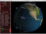
If you really want to know more about where the GPS satellites are at your location for a given time of day, here's a great freeware programme that will
not only show you the GPS birds, but any other satellite currently in orbit. Satscape is a Freeware Program for the PC. It produces real-time displays of
where any Satellite is, and predicts passes for your locale. There are about 8000+ satellites in orbit, a lot of these are just junk and debris such as
discarded rocket bodies, but quite a few are working Satellites. Passes over your part of the world can be predicted weeks in advance in a matter of
seconds. Click on the logo below for more info....
Did you know that NASA have a website that allows you to download land images taken from space? I only recently found these and they are free to
download, and can be viewed from within OziExplorer. The files are very large ranging from 7MB to 57MB, the average being 40MB. If you are
interested to explore these further visit the NASA MrSID page HERE, and for instructions on using in OziExplorer go HERE. You will need to accept a
security certificate to visit the NASA page.
Also recommended is GPS Utility, an easy-to-use application that provides management and manipulation of GPS information. You can use it to
transfer data to/from a GPS receiver and store the data in PC files in one of several text formats. The program converts between different map datums
and many coordinate formats (Lat/Long, UTM/UPS, country grids etc.). Information can be filtered in various ways and waypoints sorted according to
specified criteria. GPS Utility can also be set to gather the current position at regular time intervals and to show the position on a moving map display.
An interface monitor is available for diagnostic purposes such as logging NMEA sentences. You can also show the current position, time, speed,
course on the Position Console. - visit the GPSU homepage by clicking the logo:
Another very useful free programme is called EasyGPS, from TopoGrafix. EasyGPS is the fast and easy way to create, edit, and transfer waypoints
and routes between your computer and your Garmin, Magellan, or Lowrance GPS. Using EasyGPS, you can manage all of your waypoints and routes,
and display them in lists sorted by name, elevation, or distance. EasyGPS connects your GPS to the best mapping and information sites on the
Internet, giving you one-click access to street and topo maps, aerial photos, weather forecasts, and nearby attractions. Download it now by clicking on
the logo:
Now a Brazilian package called "GPS Trackmaker", I have not had much time to try it yet, but as the software is totally free it must be a good reason to
take a look. It does have some similarities to GPS Utility. To visit the homepage of GPS Trackmaker by Odilon Ferreora Jnr simply click on the logo:
If you really want to know more about where the GPS satellites are at your location for a given time of day, here's a great freeware programme that will
not only show you the GPS birds, but any other satellite currently in orbit. Satscape is a Freeware Program for the PC. It produces real-time displays of
where any Satellite is, and predicts passes for your locale. There are about 8000+ satellites in orbit, a lot of these are just junk and debris such as
discarded rocket bodies, but quite a few are working Satellites. Passes over your part of the world can be predicted weeks in advance in a matter of
seconds. Click on the logo below for more info....